Back to Weather

5-day forecast / The Colony, TX

MondaySunny then Slight Chance Showers And Thunderstorms96° / 76° 17%
TuesdayMostly Sunny then Slight Chance Showers And Thunderstorms95° / 77° 24%
WednesdaySunny98° / 81° 2%
ThursdaySunny98° / 81° 1%
FridaySunny98° / 80° 2%

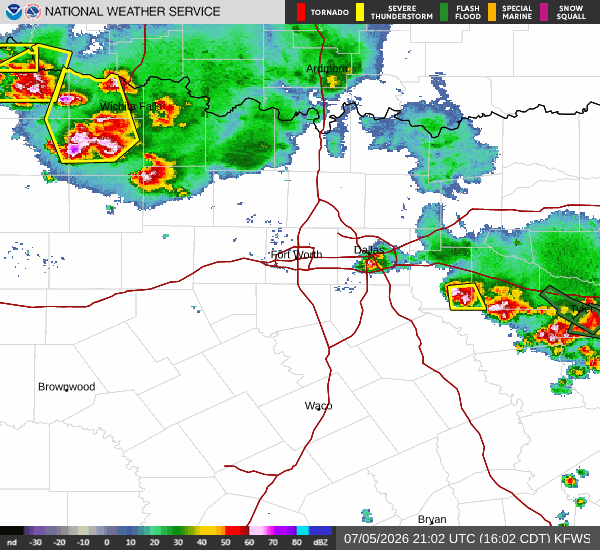
Severe Thunderstorm Watch in Effect for The Colony as Heat Index Hits 104 - Jul 5, 4 PM

The Colony weather, updated every four hours — local forecasts you can trust.

A Severe Thunderstorm Watch is active for The Colony, TX, alongside oppressive heat with a current feels-like temperature of 98F. Residents should monitor conditions closely.

Isabel Teague

July 5, 20262 min read

National Weather Service radar for North Texas (KFWS)

As of Jul 5, 4 PM local time.

Active Alerts and Current Conditions

A Severe Thunderstorm Watch is currently in effect for The Colony, Texas. This alert indicates that conditions are favorable for the development of severe thunderstorms. The watch was issued by the National Weather Service in Fort Worth and remains active until 10:00PM CDT today.

Right now, the air temperature stands at 88F, but the oppressive humidity makes it feel significantly hotter. The current feels-like temperature is 98F, with a dew point of 75F and relative humidity at 66%. Winds are blowing from the south-southeast at 7 mph, with gusts reaching up to 9 mph. The sky is mostly cloudy, setting the stage for potential instability.

Forecast for Today and Tomorrow

Today, The Colony will see a high near 99F. The National Weather Service forecasts a high heat index of 104, emphasizing the intense heat. There is a 40% chance of showers and thunderstorms throughout the day. While skies may be partly sunny at times, the humidity remains high. New rainfall amounts between a tenth and a quarter of an inch are possible. Winds will be light, around 5 mph from the south-southeast.

Tonight, the heat will linger with a low near 77F. Temperatures may rise slightly to around 79F overnight. The heat index is expected to reach 102. There is a 40% chance of showers and thunderstorms, particularly before 1am. Skies will be mostly cloudy, and winds will remain light at around 5 mph from the east-southeast. Rainfall totals could range from a quarter to half an inch.
Tomorrow, conditions will begin to stabilize. The sky will be mostly sunny with a high near 98F. The heat index will again reach 104. Winds will shift to the northeast at around 5 mph. The chance of precipitation drops significantly to just 9%. Temperatures will drop to a low of 77F tomorrow night, with skies becoming mostly clear.

Safety Reminders

Given the active Severe Thunderstorm Watch and the extreme heat, residents should stay alert for rapidly changing weather. The combination of high heat indices and potential storms requires caution. Stay hydrated and limit outdoor exertion during the hottest parts of the day. Monitor local news for updates on the storm watch and be prepared to seek shelter if severe weather develops.

National Weather Service radar for North Texas (KFWS)

Sources

https://radar.weather.gov

https://api.weather.gov

https://open-meteo.com

Share

Isabel Teague

Isabel Teague covers weather, storms, and seasonal life around The Colony.

Related Stories

More in Sport